
Bruce Myren
The Fortieth Parallel
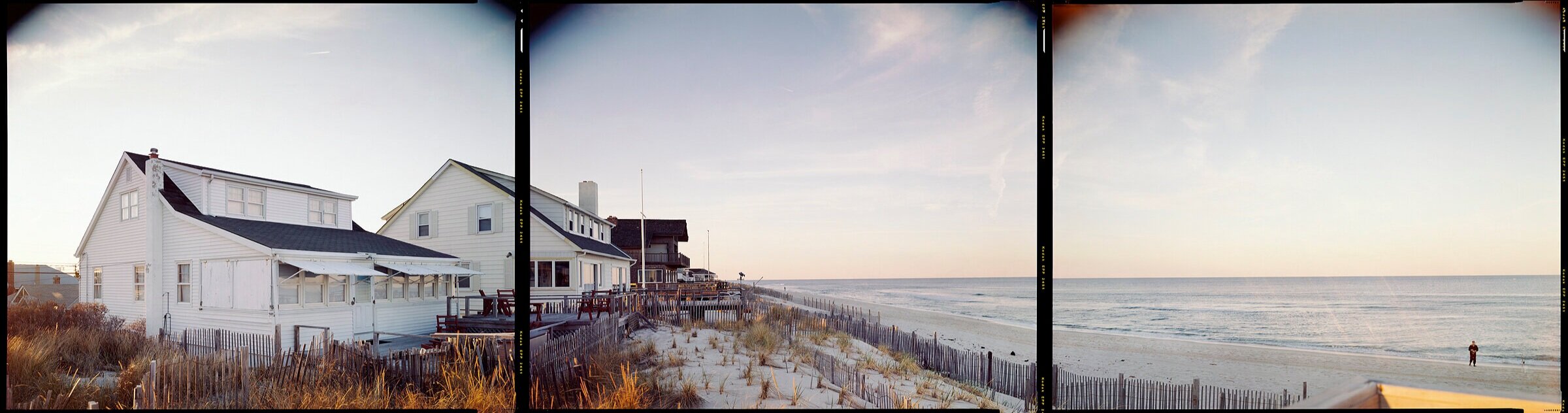
![web077[8x30].jpg](https://images.squarespace-cdn.com/content/v1/5eebac5a4787825d3794e89e/1610661827666-KFMNNO3DKX96PL9N5BG4/web077%5B8x30%5D.jpg)
![web082B[8x30].jpg](https://images.squarespace-cdn.com/content/v1/5eebac5a4787825d3794e89e/1610661847888-PS4K8J5GB88W0BKFJ9Z9/web082B%5B8x30%5D.jpg)
![web091[8x30].jpg](https://images.squarespace-cdn.com/content/v1/5eebac5a4787825d3794e89e/1610661864424-AFSDOV5ST352C1H5ER8C/web091%5B8x30%5D.jpg)
![web097[8x30].jpg](https://images.squarespace-cdn.com/content/v1/5eebac5a4787825d3794e89e/1610661882416-586E188Y33YZFM7LO1LJ/web097%5B8x30%5D.jpg)
![web109[8x30].jpg](https://images.squarespace-cdn.com/content/v1/5eebac5a4787825d3794e89e/1610661899885-X8RKR4M9LL4XZ6E9FO3P/web109%5B8x30%5D.jpg)
Gallery Kayafas is pleased to present, The Fortieth Parallel. The Fortieth Parallel is a panoramic examination of precise yet arbitrary places found along this important parallel of latitude across the American landscape. Myren, using his GPS and 8x10” camera, has photographed at each intersection of longitude and latitude beginning on the East Coast at Normandy Beach in New Jersey and ending on the West Coast at Shelter Cove, California. Once at the location, Myren allows himself twenty square feet to make a triptych of three separate images. We are excited to be showing the project in its entirety. Each of the 52 images will measure 8x30” and will encircle the gallery moving West to East.
As the baseline for surveying the Kansas and Nebraska territory, the 40th parallel defined the settlement of a large part of the western United States and a portion of it was surveyed in the 8060s by Clarence King with photographer, Timothy O’Sullivan. Using contemporary GPS technology together with an 8x10” camera, I have been photographing this line of latitude across the United States at each whole of degree of longitude. There are 50 of these confluences on land and the parallel roughly bisects the country, running from the New Jersey shoreline to Northern California. At each intersection, there is approximately a 20-square foot area in which I can compose a view. The format unties the project’s form and content, aesthetically and philosophically, and emulates a person’s entire field of vision. Not wanting to re-make O’Sullivan’s pictures or simply record topography, I see the project instead as a personal survey and one that engages the nature of how humans circumscribe and conceive the world.
This series unites my interest in mapping with conceptually-based art practices and references several “histories”—my father’s history as a surveyor, my interests in maps and systems, the history of the mapping of the United States and photography’s role within it, and the history of GPS and locative technologies. This work began in 1998, before GPS selective availability was lifted, and was completed in 2012. By documenting the seemingly random terrain found at these intersections, I invite the viewer to consider the history of landscape, land use, and the built environment as well as their own relationship to place. -Myren
Myren received his BFA from the Massachusetts College of Art and Design and his MFA from the University of Connecticut at Storrs. Shown nationally and published internationally, Myren's work has been featured in Fraction Magazine, afterimage, and View Camera Magazine as well as group exhibitions at the Phoenix Art Museum, RISD Museum's Chace Center, Houston Center of Photography, and the William Benton Museum of Art, among others. His numerous solo exhibitions include showings at the University of the Arts, Danforth Museum of Art, and Gallery Kayafas in Boston, where he is represented.